Our modelling philosophy
Landscape change arises from interaction and feedback among semi-independent processes that react to and change the landscape state.
Models of landscape dynamics can be constructed by implementing these processes as separate sub-models that can communicate indirectly via state changes, and do not need to have direct communications.
This modelling worldview allows models to be built that are as simple as possible (following Occam's razor) yet have very complex emergent dynamics.
Model implementation should be as transparent as possible to allow others to understand the "beauty" of the model
separately from the "beast" of the overhead code needed to get the model to run on the modelling platform.
Model building tools should support thinking about the model building process,
This was the insight we had when SELES was first conceptualized (Fall & Fall 2001).
We expected SELES to have been superceded by now by an improved declarative model building platform for landscape systems analysis.
We are not yet aware of a more refined declarative system for modelling landscape dynamics, and SELES continues to be useful in part because we continue to see the same shortfalls in many new landscape models that motivated us to develop SELES.
What is SELES?
SELES (Spatially Explicit Landscape Event Simulator) is a tool for constructing and running spatio-temporal (dynamic) landscape models over long time-frames and large spatial areas.
SELES models can integrate natural and anthropogenic processes
(e.g. fire, insect outbreaks, logging, succession) and track indicators (e.g. age class, habitat supply, timber volumes).
SELES has extended research in the fields of landscape ecology, simulation and ecological modelling, and has been used as a tool for research on
sustainable landscape management,
natural disturbance modelling and habitat modelling. It has been used as a core component of many M.Sc. and Ph.D. dissertations across Canada and internationally, to support significant
landscape management and land use decisions in B.C., and part of many research projects.
What is it exactly?
It can sometimes be difficult to identify what exactly a software application or modelling tool does from high-level descriptions
(which tend to make tools seem broader than they are in reality).
The following is an attempt explain the preceding section with more specifics.
SELES has several facets:
(a) A state-space specification language (.sel files) to create a raster-based spatio-temporal state space.
This is used
to define the spatial extent and resolution of a model, spatial variables and constants, global variables and constants (including tables),
process sub-models, and other elements.
(b) A declarative (and non-linear) modelling language (.lse files) to specify landscape dynamics and pattern analysis
within that state space. Landscape events and landscape agents are semi-independent sub-models that navigate through
space and time, and make state changes along the way. One philosophical underpinning of SELES is that these
sub-models interact directly only with the state space, and interact indirectly via changes to that state space.
This allows complex models to be built in a manageable way.
(c) A scripting, or scenario, language (.scn files) to load inputs and models and to control model runs (similar in many ways to other procedural scripts).
(d) A program (seles.exe) to run scripts and models - made freely available for download.
The core of SELES is a discrete-event simulation engine (for scheduling and
processing events in order of simulated time) and the algorithms for running landscape events and
landscape agents (the diversity of options requires a diversity of algorithmic solutions).
(e) A text editor (LSEditor.exe) to edit and parse model files, also included in the download.
What is a landscape event?
The concept of a landscape event was one of the first insights that originated SELES. A landscape event
is a meta-model (i.e. a generalized model of a class of models)
of a process that navigates through space and time and makes changes to the landscape state.
"Natigating through space and time" means identifying the locations (grid cells) and times when changes are to occur (e.g. when a fire burns or a road is built).
This involves periodically returning (e.g. annual or variable time steps), initiating in one or more locations, and potentially spreading at appropriate rates (usually to neighbouring cells).
For example, a logging event may initiate in forested cells that are available for logging (e.g. old enough, with road access and not reserved for objectives), and spread to adjacent
available cells until a target size is reached or until there are no more available adjacent cells).
Of course, there are many details that may be used to control when events return, where they may initiate, how many initiations, where they may spread (e.g. immediately
adjacent neighbours or allowing skips), how fast
they spread, and when spreading stops (e.g. emergent, top-down or both).
This meta-model has proven useful for a very wide range of processes and model types, including cellular automata (no spreading), diffusion (e.g. percolation-type models),
population models, planning, connectivity (e.g. spatial graphs), hydrological flow, etc.
In the high-level SELES modelling language, landscape events are specified using properties
that declare model behaviour, but not the exact details of how.
Properties include Probability of Initiation (the relative or absolute probability of selecting a raster cell) and Number of Clusters
(the number of initiations). There are about a dozen properties, and only those relevant for a modelled process need to be specified.
State changes are associated with the model properties - that is, once a model is moving through space
and time as desired, one can specify changes to state in the
approprate contexts (i.e. a specific location and time).
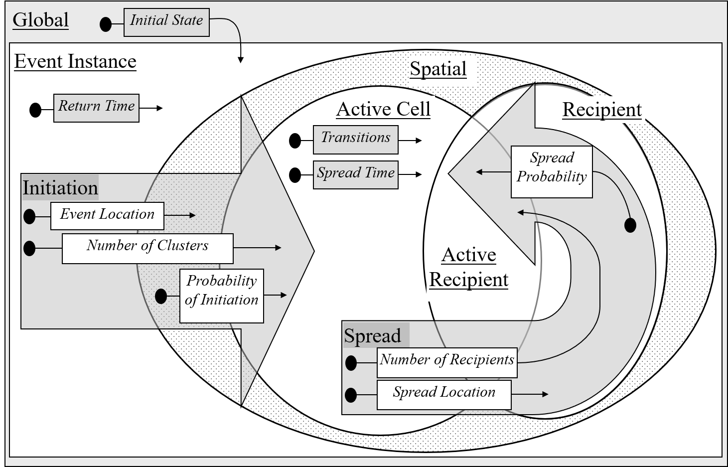
This generalized algorithm of a landcape event is shown in the following diagram.
I won't explain it here other than to write that it represents how landscape events return, initiate in
cells on the landscape and spread. Mastering modelling in SELES is synonymous with fully understanding this diagram (which is dealt with
in detail in the documentation and training material).
How can I learn to use SELES?
The user documentation (included in the download) has been updated and explains these facets
(in much more detail than feasible on a website).
The self-learning material includes example functional models, and some high-level and simplified explanations.
The projects page provides an overview of some projects
of different types that have been
implemented in SELES, while the publications page lists many of the articles and reports based on SELES models.
Why is it free? Why not (see Copyright/left page for our philosophy on providing SELES and SELES models for free).
But because it is free, don't expect a web site with fancy graphics - illustrations can be found in the learning material and
graphics that are made from the beautiful emergent properties of your models.
SELES Origins
The first version of SELES originated from a course project by Andrew Fall and Joseph Fall in 1996 in a graduate level modelling course in Resource and Environmental Management at Simon Fraser University (SFU), B.C.
While it was very limited (and wasn't yet a modelling language), it did have the essential concept of a landscape event, which was used to
represent percolation-based fire spread models.
These modest origins led to interest from Don Morgan and Marvin Eng, landscape researchers in the B.C. Ministry of Forests, and later a
grant from Forest Renewal B.C. supported continued cross-disciplinary research between Resource and Environmetal
Management and Computing Science at SFU from 1997-1999.
The first applied models were developed with Marvin Eng (grassland-forest dynamics in the central interior of B.C.)
and Don Morgan and Dave Daust (natural disturbance, logging and caribou habitat supply in the Rocky Mountains and Columbia Mountains of south eastern B.C.).
The novelty of these early projects led to a proliferation of interest that both expanded the depth and breadth of models to include
more detailed fire models (in Birkenhead area of southwestern B.C.), red-legged frog population modelling (with researchers at the University of B.C.),
bird dispersal movement (with researchers at Université Laval),
snag population dynamics and spatial graph-based connectivity.
One branch of these more research-oriented projects led to many projects with Marie-Joseé Fortin
(University of Toronto), Christian Messier and Dan Kneeshaw (Université de Québec à Montréal) and many others, in particular
for projects in Québec and Labrador as part of a Sustainable Forest Management Network project.
In the early 2000's, the large Mountain Pine Beetle (MPB) outbreak started in northwestern B.C.
Connections with MPB researchers Les Safranyik, Terry Shore and Bill Riel at the Canadian Forest Service led to development of a landscape scale MPB population model,
the Provincial scale BCMPB model and MPB host connectivity studies.
Concurrently, SELES started being used to support strategic land-use planning processes in coastal and
northwestern B.C. (North Coast, Morice, Haida Gwaii and Great Bear Rainforest), with Don Morgan and many others.
This work has continued with a increasing collaboration with First Nations, and expanding into support for the coastal carbon projects that arose from these land use plans.
In 2002, the first version of the SELES Spatial Timber Supply Model (STSM) was developed collaboratively
with Forest Analysis and Inventory Branch, B.C. Ministry of Forests, and based
in part on the models used to support land-use planning.
These models were pushing the limits of memory on 32-bit machines, and the Ministry maintained and
adapted one version of the STSM while I continued to develop a different version.
In 2020, a consolidated version of STSM was created, enabled by the release of the 64-bit version
of SELES, and included expanded capabilities (and complete documentation).
This forest landscape model is currently one of the main tools used for timber supply analysis in B.C.
We have continued to improve SELES over the years, porting it to 64-bit, increasing the efficiency of the core simulation engine,
expanding features, and updating documentation (documentation used to be provided online on "seles dot info", by the generous time and energy of Charles Burnett,
with whom I worked on several projects,
but unfortunately that
became untenable to maintain - hence documentation is now maintained as a PDF included in the download).
How long will SELES continue to exist? As long as I have time and energy, and as long as no other modelling tools are created that makes it obsolete (and then I can retire...).